More deserted farmsteads …

Well, this is Bwlchygelli, at ST 16711 84736

just where John Owen said it would be, in the dip between Blaen-nofydd and the Heol Hir.

Can’t think why I hadn’t spotted it before. Perfectly obvious that heap of stones was once a building.

‘ Brains first, and then Hard Work’ said Eeyore.

John Owen suggests Bwlchygelli and Bwlchylechfaen  could originally have been squatter settlement on the older estates of Cefncarnau and Cefneinion. There was lead working in the area, and there are the remains of quarries and limekilns on the lane from Blaen-nofydd – this is the limekiln at ST 16595 84695.

Both farms were small, not much more than smallholdings: possibly early industry provided some casual work for wages, with the farm worked mainly by the women of the family for sustenance. That was quite a common pattern in early industrial areas.

I’m still not sure about Ty-Draw, though. There’s no evidence of a structure down the hill.

There are some possible features just below the track,

but the house marked on the tithe plan is further down. Part of the problem is that we are on the edge of 3 parishes so the lines on the plan don’t totally match up, but I’m wondering if it could be further down the slope again, below the track that goes towards Cefn Carnau Lane.

(Also it’s Ty Drav on the map but I’m sure it should be Ty Draw.)

Nell will be pleased to have another look.

All that’s left of Ty’n-y-parc now seems to be this ruined cowshed at ST 17830 85903,

though there are some tumbled stones under the trees.

John Owen remembered a forester living there in the late 1950s but the forest has now completely taken it over.

Another puzzle. The farm marked as Cefn-carnau-fach on the early and current OS maps is the one which is called Cefn-carnau-uchaf on the tithe plan. The farm called Cefn-carnau-uchaf on the OS is just Cefn Carnau on the tithe plan. Who is right – or did the names change?

Lost farms, lost settlements

To distract us during the lockdown, while we can’t do much in the way of fieldwork, we’ve been having a discussion on Twitter on the mapping and listing of deserted settlements. @DrFrancisYoung asked if anyone had ever done an atlas of all England’s deserted villages – so I said ‘and the Welsh ones’. It was suggested that Wales needed a separate volume – fair enough, there are differences, different settlement patterns, much more dispersed settlement, hamlets rather than villages. Also the perennial problems of funding and getting it noticed. Then @A_N_Coward rather proved my point by pointing out that our online resource Coflein ‘has site types for ‘deserted settlement’ and ‘deserted rural settlement’ with about 400 sites between them (although there’s probably some overlap) and a nice distribution across Wales. Many have pics (mostly aerial photos): https://coflein.gov.uk/en/site/search/result?PCLASSSUB=97280&SEARCH_MODE=COMPLEX_SEARCH&view=map https://coflein.gov.uk/en/site/search/result?PCLASSSUB=500312&SEARCH_MODE=COMPLEX_SEARCH&view=map

so actually we seem to have done it. Mind you, there’s some debate about what constitutes a settlement – how many cottages?

Meanwhile, my walks with my neighbour’s dog had taken me over towards the Wenallt, just north of Cardiff, and the little valley of the Nant Cwmnofydd: and at about grid ref ST 14702 83939 what should I find but what looked like the ruins of a row of cottages.

And in the Wenallt woods themselves, at about ST 14959 83860, another farm or group of cottages.


I wondered on Twitter how old they were, what the people who lived in them did for a living, and when the Record Office would be open again.

@DrIestynJones  pointed me in the direction of http://geoarch.co.uk/reports/1999-06%20Wenallt520slags.pdf which is a report on some early ironworking slag and other remains further down the Cwmnofydd. I don’t think the cottages were that old – but where there was medieval ironworking there may have been post-medieval working as well.


Several people pointed me to online maps, including @MusicNLW  who led me to the National Library of Wales’s amazing Places of Wales site https://places.library.wales/ . You need a place name to get in but once you are there you can scroll around, look at the 1840 (ish) tithe plans, an old OS map (2nd edition, I think, early C20) and the modern map (Google not OS, alas, so not brilliant for anything off road). Then you can pull up data from the tithe surveys – field names, crops, tenants and owners. It can be tricky tying up early C20 trackways with modern rights of way but it’s doable.

A bit of work on that suggested that my first batch of photos was not a row of cottages but a whole little farm, Cwmnofydd (about grid ref ST 14702 83939). It was there on the early C20 map and presumably occupied – one wonders when it was deserted and how it became so completely derelict. There are other lost farms in the area – Cefncarnau Fawr, up on the ridge to the north, around ST 15053 84409, was a big farm complex with a massive barn and other outbuildings

but that too is completely lost.

I still can’t identify the site on the other side of the stream at around ST 14959 83860. It doesn’t seem to be marked on the 1840 map so it may have been deserted and in ruins by then.

Walking a bit further with Nell the spaniel got me to the other side of the main road over Caerphilly Mountain and along the lane to the Heol Hir. Here the trees were cleared a couple of years ago and you could see the foundations of another little farm at ST 16943 84871 (easier to see just after the trees were cleared)

– here it is now

I found this one on the 1840 plan – I thought in the original posting that it was Bwlch-y-Gelli but it’s actually Bwlch-y-Llechfaen so I’ve corrected it (a bit difficult to identify as we were on the edge of 2 plans and they didn’t quite match up). That too was still there in the early C20 but it’s now just a little bit of tumbled stone under the brambles.

It’s often surprising how quickly a building can degenerate into a ruin. This is Penybryn Cottage, on the road between the Black Cock and Rhiwbina Hill at about ST 14293 84426.

.

My father-in-law remembered it in the 1930s or 1940s with a huge family living in it. Once the roof goes, the whole building goes.

Penybryn Cottage is on the map but I couldn’t find this one,

across the road and a bit further uphill. Quite a substantial building, with its own bread oven.

There are others that aren’t on the map. A traditional platform house near the top of Castell Coch woods, round about ST 14009 83746:

and some ‘structures’ around the iron-mining pits, a little further into the woods, round ST 13876 83545 (these grid references are a bit vague).

These might just be spoil heaps from the iron mines but this one looks rather rectangular. (It was actually easier to see before the trees were felled.) Probably not a house either, though – somethig to do with the iron mining? The whole area is pockmarked with diggings for haematite iron ore,

some of it probably 16th and 17th century.

When Natural Resources Wales were preparing to fell the conifers on this side of the forest because of the dreaded phytophthora ramorum, they said they had a detailed survey of things like the iron pits and possible charcoal burning platforms, something like a Lidar survey. I wonder if it’s ever going to be publicly available?


And I must remember that @AncientTorfaen  wanted to know what colour the mortars in the old houses were.

Swansea the Riverside Town

Gerald Gabb has sent me the following information about his magnum opus – the completion of his 3-volume history of Swansea.

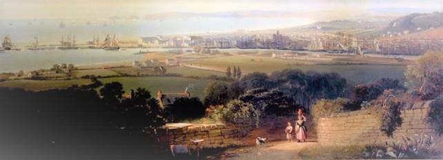
The 1840 view above by Alexander Rolfe (Glynn Vivian Art Gallery) decorates the slipcase of my new book, “Swansea the Riverside Town”, which has been 12 years in the making.

It will be launched on Saturday 18th and Sunday 19th May between 10 and 4.00 at Swansea Museum – full details here.

book details


If that date does not suit, there are –


Further launches at Sketty, Newton, Bishopston, Reynoldston, Mumbles, the Central Library and in Swansea Market


As well as talks and events in the National Waterfront and Swansea Museum, and at Clydach, Fforestfach, Glynneath, Gowerton, Killay, Llansamlet, Loughor, Morriston, Neath, Penlan, Pontarddulais, St.Thomas and Trallwn, at which the book will be available.

Dates, times and venues are given below – just scroll right down.


It’s an expensive book, so anybody coming to have a look at it, or only to hear the talk and have a chat is sincerely welcomed. All talks are planned as being interesting in themselves – they are not just adverts.


You can also get in touch via g.gabb@ntlworld.com or 01792/613262. In that way you can arrange delivery of a copy, or call in to see one at 38 Woodland Avenue, West Cross SA3 5LY.

                                                                                                                       Keep going down !

Or try a shop:     Swansea Museum (open Tues-Sunday, 10-4.30)

Cover to Cover, Newton Rd., Mumbles

Waterstones, Oxford Street, Swansea

Norton Stores (opposite the Beaufort)

or further afield at College Street Books, Ammanford or Seaways Bookshop in Fishguard.

TALKS & EVENTS

Pre-publication talks

Saturday 13th April 2.30 RISW lecture, Swansea Museum


Wednesday 17th April 3.00 SKETTY LIBRARY


Thursday 25th April 2.00 TOWNHILL LIBRARY


Saturday 27th April 11.00 HISTORICAL ASSOCIATION, National Waterfront Museum


Talks & events at which the book MAY be available

Saturday 4th May PENNARD LIBRARY 10.30


Tuesday 7th May OXFAM BOOKSHOP, Castle Street 7 for 7.30


Wednesday 8th May 7.00 OYSTERMOUTH LIBRARY please ring, email or call in for a ticket: 368380  judy.knight@swansea.gov.uk 


Saturday 11th May Local & Family History Fair, NATIONAL WATERFRONT MUSEUM, 10-4.00

with talk at 11.30


Wednesday 15th May PENLAN LIBRARY 10.00


Formal Launch

Saturday/Sunday 18th/19th May  SWANSEA MUSEUM, 10-4.00 both days

On Saturday, Prys Morgan (11.30) & Peter Stead (2.30) have kindly agreed to speak.

The author will give presentations at 11.00
on Sunday. The book will be available throughout both days.


Follow-up launch sessions

Thursday 30th May 10.30-12.30 ST.PAUL’S PARISH CENTRE, Delabeche Rd, Sketty,

                                                                         talk at 11.00 (ample parking)


Saturday 1st June 9.30-4.00 SWANSEA MARKET table in the centre, chat but no lecture


Saturday 8th June 10-1.00 NEWTON VILLAGE HALL, by St.Peter’s Church, talk at 11.00


Thursday 13th June 7.00 Tabernacle Chapel Hall, Chapel Street, Mumbles – a COVER to COVER  BOOKSHOP event – please book: sales@cover-to-cover.co.uk, 01792/366363 or at the shop


Saturday 29th June  ST TEILO’S PARISH HALL, Bishopston 10.30-12.30 talk at 11.00


Saturday 20th July 2.00 SWANSEA CENTRAL LIBRARY Discovery Room, upper floor


Friday 26th July Reynoldston Village Hall 6.45-8.30 talk at 7.20


Saturday 27th July, 10.00: Swansea History walk led by Gerald Gabb, beginning and ending at Swansea Museum – roughly 2 hours, level throughout. Tea & coffee available at the museum on return. For further details contact John Steevens, john@steevens.co.uk or 01792/643791 ALL WELCOME (Royal Institution of South Wales event)


Other talks & events where the book will be available

Monday 3rd June FFORESTFACH LIBRARY 10.30


Wednesday 5th June 2.00 circular Swansea History walk led by Gerald Gabb, – about 2 hours, level, meet at Swansea Museum (a Gower Walking Festival event, places limited, book at info@gowerwalkingfestival.uk or on 07340/672963)


Friday 7th June U3A Family History group 10-12  members only


Tuesday 11th June 10-12.00  Swansea Eastside Historical Society,

Community Room, St.Thomas Community Primary School


Tuesday 11th June 7.00 GOWERTON LIBRARY


Friday 28th June 2.00  KILLAY LIBRARY


Wednesday 3rd July 2.30 LLANSAMLET LIBRARY


Saturday 6th July 2.00-3.00 PONTARDDULAIS LIBRARY


Friday 20th September 7.00 CLYDACH HISTORICAL SOCIETY, Clydach Community Centre


Saturday 28th September RISW/HA History Day in the museums 10-4.00


Friday 11th October 2.30 LLANSAMLET HISTORICAL SOCIETY Trallwn Community Centre


Thursday 17th October 8.00 OYSTERMOUTH HISTORICAL ASSOCIATION Ostreme Centre


Saturday October 26th RISW Local History Bookfair, Swansea Museum 10-4.00


Wednesday 6th November 7.00 GLYNNEATH HISTORICAL SOCIETY Glynneath Training Centre


Thursday 7th November 2.30 LLWCHWR HISTORICAL SOCIETY the Institute, Lime St., Gorseinon


Tuesday 12th November 7.30  KENFIG SOCIETY Pyle Parish Hall


Monday 18th November 7.00 NEATH ANTIQUARIAN SOCIETY the Old Town Hall


Tuesday 3rd December 2.00 MORRISTON LIBRARY


…….and probably a summer talk at the Glynn Vivian, details to follow


SHOPS  try Swansea Museum, open 10-4.30 Tuesday to Sunday

or Cover to Cover, Newton Road Mumbles, and Waterstones in Oxford Street all of whom have been very supportive. Norton Stores (formerly Ian Boyd’s) will have copies, as will College Street Books, Ammanford and Seaways Bookshop in Fishguard. Waterstones in Oxford Street and the National Waterfront Museum may also be stockists.


Payment

At the time of writing it is hoped that a card reader may be in use, but, to be safe, please bring cash, or, that old fashioned item, a cheque-book.


Llanfair-ar-y-bryn

The main purpose of our visit to Llanfair-ar-y-bryn was to check the memorial to the great Welsh hymn-writer William Williams Pantycelyn and his family (see https://welshtombs.wordpress.com/ ) but there was a lot else of interest in and around the church. It stands on the site of a Roman auxiliary fort, and there is Roman tile and brick in the church walls.

The church was built by the Norman Robert Fitzpons, who built the first Llandovery Castle. He established a small Benedictine priory here, dependent on the abbey at Malvern. When the area was reconquered by the Great Lord Rhys, he allowed the monks to remain, but they were turfed out by his son Rhys Gryg in 1185. (The story is that the behaviour of the monks had become scandalous. These little dependent priories could go bad, but theat may have been an excuse.)

The church was deliberately damaged by fire. It was rebuilt by Sir John Giffard when he was constable of Llandovery castle. There were later alterations – the installation of a rood screen, some new windows. The floor of the original church sloped down hill to the east, but at some point the chancel floor was raised, leaving two rather odd windows low in the east wall.

The church as it stands is big enough, but it was even bigger at one time. There was a south transept, but it was in ruins by the eighteenth century and used as a dumping ground for skulls and bones from the graveyard. There may also have been a north transept.

Inside, on the north wall, is this medieval cross slab.

Probably mid-late 13th century, measures 88.5 x 32 cm maximum. Turn it upside down

and the inscription reads …S: CVIV… (in other words, …s, cuiu[s anime deus propitietur], on whose soul may God have mercy).

There is also a strange little face with jug ears


– could this possibly come from an effigy? There are two sepulchral niches in the north wall of the chancel, one part obscured by subsequent rebuilding.

The church also has a little bit of decorative medieval paint and this

probably late 16th or early 17th century text, so far undeciphered. It could be Welsh;

the medieval font in which William Williams was baptized;

and some rather splendid hatchments of the local Gwynne family.

And the King’s Head in Llandovery does a full vegan menu including some vegan chocolate brownies.

Cross slabs – medieval and post-medieval

posted in: Tombs, Welsh History | 0

Really looking forward to speaking to Cardiff’s Continuing Education series of free lectures next week. The talk will involve telescoping two lectures into one, and as it’s part of the History programme I thought some further reading might be appropriate. To my embarrassment I find a lot is things I’ve written myself …


Some background reading on medieval cross slabs:

McClain, A. 2010. ‘Cross Slab Monuments in the late Middle Ages: patronage, production and locality in Northern England’, in S. Badham and S. Oosterwijk (eds), Monumental Industry, Shaun Tyas, Donington, 37-65.

This is a good introduction with a lot of further references to the work of Peter Ryder and Lawrence Butler – e.g.

Butler, L. A. S. 1964. ‘Minor medieval monumental sculpture in the East Midlands’, Archaeological Journal, 121, 111-53

Ryder, P. 1985. The Medieval Cross Slab Grave Cover in County Durham, Architectural and Archaeological Society of Durham and Northumberland, Durham


On Welsh cross slabs:

Gresham, C. 1968. Medieval Stone Carving in North Wales, University of Wales Press, Cardiff

– still a useful introduction but see

GITTOS, B., and GITTOS, M. 2012. Gresham revisited: a fresh look at the medieval monuments of north Wales’, Archaeologia Cambrensis, 161, 357–88


On the Llangynwyd cross slabs:

Gray, M. 2012-13. ‘Good thief, bad thief: some thoughts on the medieval cross slabs of south Wales’. Welsh Journal of Religious History 7 & 8, 24-38, and

Gray, M. 2017. ‘An unrecorded triple cross slab at St Mary Hill’. Morgannwg 61.


On the post-medieval cross slabs:

Gray, M. 2016. ‘Post-medieval cross slabs: closet Catholics or stubborn traditionalists?The Antiquaries’ Journal. 96, p. 207-240. Available online at https://pure.southwales.ac.uk/en/publications/postmedieval-cross-slabs(39f0b31f-d6e5-4bc6-b255-2750950fe7ee).html .


Online resources:

There are several posts on my https://welshtombs.wordpress.com/ blog – e.g. https://welshtombs.wordpress.com/2013/07/05/brecon-cathedral-history-beneath-your-feet/ , https://welshtombs.wordpress.com/2013/10/31/on-the-benefits-of-a-fresh-pair-of-eyes/ , https://welshtombs.wordpress.com/2015/11/06/abergavenny-three-more-post-reformation-cross-slabs/

and on the Tintern inscriptions, https://welshtombs.wordpress.com/2018/06/16/tintern-abbey-the-commendation-of-souls/

On the Llangynwyd cross slabs, https://churchmonumentssociety.org/monument-of-the-month/heaven-under-our-feet-the-laleston-triple-cross

and on Brecon https://churchmonumentssociety.org/monument-of-the-month/brecon-cathedral-a-post-reformation-cross-slab and https://churchmonumentssociety.org/monument-of-the-month/brecon-cross-slab-commemorating-lewis-havard-d-1569


The Church Monuments Society is for everyone who is fascinated by tomb carvings – medieval effigies, cross slabs, modern gravestones. Their web site is at https://churchmonumentssociety.org/

and the Ledgerstones Survey http://www.lsew.org.uk/ focusses on stones set in church floors – cross slabs, heraldic designs and others.


Finally, not really to do with cross slabs, but this thesis https://pure.southwales.ac.uk/en/studentthesis/death-and-commemoration-in-late-medieval-wales(7d14b42e-a69b-4968-9398-aad3b96748e0).html looks at different kinds of commemoration but also has a lot of detail on evidence for tomb carvings and burial practices.

Betty John Cefn Llwyd

I had a lovely afternoon exploring my mother’s reminiscences with our village Mothers’ Union last week. They all remembered her as the elegant elderly lady who came to Evensong and were intrigued by the story of her childhood on a farm between Newport and Cardiff and her struggle to get an education. I have promised to go back again and talk about her time at university and the war years in Chepstow.

I rescued her reminiscences and put them on this site but on a page which talked about her last illness and death. Here they are again without that rather sad introduction.

Reminiscences of farming life in the 1920s

Education for the people

War Years in Chepstow

Larkfield Grammar School in World War II

Chwyldro! Chartist events this autumn

posted in: Welsh History | 0

It’s going to be a Chartist autumn …

Sponsored by Our Chartist Heritage (OCH) and CHARTISM e-Mag:

10th Annual Newport Chartist Convention 2016
Saturday November 5th     09.30 – 16.30
Venue: JOHN FROST SCHOOL,
Lighthouse Road, Newport, NP10 8YD

The school (formerly Duffryn High School) is marking its adoption of the name of the iconic Newport Chartist leader
by hosting this year’s convention.
For programme details, location map and to book your place

GO TO  https://chartist-convention-2016.eventbrite.co.uk

Tickets are £10 with lunch
£7 without lunch
£3 student with lunch
£0 student without

This year’s keynote speaker is Professor Malcolm Chase (Leeds University), who will be exploring Welsh Chartism in the aftermath of the Newport Rising of November 1839
Throughout the day, pupils will pay tribute to the Chartists through musical and other artistic contributions.  Other speakers include: Dr. Katrina Navickas, Peter Strong, Dr. Elin Jones, Catrin Edwards, Sarah Richards and Les James.


ALSO JOHN  FROST is ‘APPEARING’ in the Australian made Film

‘DEATH OR LIBERTY’  touring SOUTH WALES
24th & 25th November 2016

Dr. Tony Moore (Monash University, Australia), author and film maker will introduce and discuss his film at Three Venues:

CARDIFF, NEWPORT and MONMOUTH

There will be a special OPEN FORUM held at GWENT ARCHIVES (Ebbw Vale) to discuss development of a transnational POLITICAL CONVICTS PROJECT attended by Tony Moore and other Australian guests.

See link below for full details of this Tour and the forum
and how to order your tickets

death-or-liberty

And finally:

Prof Paul Pickering, Dean of the Australian National University, will give a paper on the implication of Chartism on the international stage on Friday, 4 November at 7.30 pm at the Newport City Campus of the University of South Wales. This was arranged by Dr Richard Allen and is sponsored by the Humanities Research Institute of the University.


Knowing where you live

posted in: Welsh History | 0

It is just a bit disconcerting to realise that you can live somewhere for getting on for 40 years and not know everything about it. First there was the little house in the big woods: walking through the top of Castell Coch woods above my house in Tongwynlais, at just the right time of year, I realised that this

SAM_1645

was not upcast from an iron mine but the remains of an old cottage, built long-house style on a platform dug into the slope. Once you know it’s there you recognise it even when it’s covered with a deep carpet of wild garlic.

2015-05-17-15-45-54

Then it was the slope between the castle and the mini golf course. From the castle it looks as though the ground simply falls away steeply through the trees. But walking along the path above the golf course I realised there was something on the other side. Scramble up the bank, down the precipitous slope on the other side and you find this –

2015-05-24 15.58.33

a deep cutting running for several hundred yards

2015-05-24 15.56.49

terminating in a cliff face

2015-05-24 15.51.35

then above it a smaller cutting running up to the castle.

2015-05-24 15.45.19

I knew all about the quarrying that created the dramatic cliffs below the castle to the west. According to some correspondence in the Bute estate archives, an agent from Dowlais travelling to Cardiff in the early nineteenth century noticed that blasting in the quarry below the castle was shaking the ruins to their foundations. He contacted the Marquess of Bute who ordered the quarrymen to stop. But no-one seems to have recorded anything about quarrying on the other side of the castle. Was it digging for stone – or was it more digging for iron?

Back to the maps …

The Cross of Destiny

posted in: Welsh History | 1

Sometimes it’s the things that everyone knows that turn out to be the most puzzling – and also the most illuminating. A couple of years ago we had an interesting discussion on the medieval-religion Jiscmail list (http://www.jiscmail.ac.uk/medieval-religion) about the Croes Naid, the fragment of the True Cross which was the most valued part of the regalia of the Welsh kings of Gwynedd. The name has been variously translated as the Cross of Destiny or the Cross of Refuge (by the Geiriadur Prifysgol Cymru, Wales’s equivalent of the OED: see http://anglonormandictionary.blogspot.co.uk/2013/02/word-of-month-croes-naid.html and http://www.welsh-dictionary.ac.uk/ ). Seized by Edward I after his defeat of Llywelyn and Dafydd ap Gruffydd, it ended up in St George’s Chapel, Windsor, where a carved boss still depicts its reliquary. But its journey there was anything but simple.

For Christmas my lovely husband gave me a book on the graveyards of the City of London (how well he knows me). I want to visit them all. We made a start on a recent visit by taking a line from Bunhill Fields to St Olave Hart Street. On the way we passed St Helen’s Bishopsgate: nice little graveyard, now a garden between high office blocks and in the shadow of the Gherkin.

SAM_1799

People were coming out of the lunch-time Bible study – men in expensive tailoring, students in jeans, lots and lots of people. In we went. The church was still full and buzzing, people eating sandwiches, other tourists wandering around, a couple of meetings in the transept. Eventually a welcomer came up to us, answered a few questions and lent us a copy of the church guide book. (Yes, we did go and buy a copy of our own.) The welcoming strategy was Good – let people look around first, approach them with a welcome, ask a few open-ended questions, decide they were academics, offer some literature, let them get on with it. Then she discovered we were Welsh and introduced us to the minister. He is Welsh. He speaks Welsh. We still get everywhere.

St Helen’s (formerly the nunnery of St Helen) is one of the City of London’s few surviving medieval churches, with a stunning collection of medieval and post-medieval tombs and a remarkable claim in the guide book. We were told that in 1285 Edward I gave the church a cross called Neit which he had ‘found’ in Wales. So if the Croes Naid was in Bishopsgate, what was in Windsor?

Back home, I sent a hopeful email enquiry to the church. I was worried that relics and relic cults could be tricky for evangelical Anglicans but the current and previous building managers got back to me with encouraging speed. The guide book was based on the Survey of London volume – which referenced Edward I’s wardrobe accounts and the Rolls Series edition of his chronicles – then I found my notes from the earlier discussion on medieval-religion with some online articles and a few more references to edited texts. Back to the literature. I’m still happiest if I have some paperwork.

We still don’t know where the Croes was before it was surrendered to Edward I. In Celtic Britain and the Pilgrim Movement (p 100) Griffith Hartwell Jones says it was on Llywelyn’s body when he was killed, but he gives no source for this and the sources he quotes for the hand-over of the Croes don’t say where it was found. Personal reliquaries were common, and it is quite possible that Llywelyn would have wanted this precious relic as near to him as possible: but if he was killed by an English raiding party (and his body was subsequently mutilated and his head taken and placed on Traitor’s Gate in London) how did the relic remain in Welsh hands to be surrendered the following year? Other traditions suggest it was kept by the Cistercian monks of Aberconwy. It was certainly at Conwy that it was handed over to Edward. The Aberconwy community had been moved from Rhedynog-felen, near Clynnog, by Llywelyn’s grandfather Llywelyn ab Iorwerth, who wanted them nearer to his palace at Deganwy. Llywelyn ab Iorwerth himself took the monastic habit at Aberconwy shortly before his death and was buried there.

The Welsh Rolls of Edward I describe the Croes being handed over at Conwy by ‘Einion son of Ynor, Llywelyn, Dafydd, Meilyr, Gronw, Deio and Tegnared’: as a reward they were released from any other royal service. (Rot. Wal. 2 Edw. 1 m. 1; Rymer, Foedera, i, 63). On the other hand … according to the chronicle of William Rishanger, a monk of St Albans (online at https://archive.org/stream/willelmirishange00rish#page/104/mode/2up ), it was Dafydd ap Gruffydd’s secretary who brought the relic to Edward. This was presumably the Hugh ab Ithel who was given a scholarship at Oxford as a reward (Hartwell Jones found this in the royal wardrobe accounts for 1284). The royal warrant recording its surrender stated that the relic had been passed from prince to prince down to the time of Dafydd ap Gruffydd. It looks rather as though the relic had been in safe keeping somewhere, but not necessarily at Conwy, which was in Edward’s hands by the end of 1282. The rulers of Gwynedd had close links with the abbey of Cymmer and Llywelyn ap Gruffydd was buried at Cwm-hir. Both are possible candidates.

Dafydd was still alive when the Croes was handed over. In September he suffered the horrific death of a traitor, being hanged, drawn and quartered, the four parts of his body sent to the four quarters of the kingdom and his head placed on the Tower of London. All this rather puts paid to Edward’s claim to have ‘found’ the relic in Wales. This was more than a simple surrender: it was forcible translation of the relic, on a par with Edward’s ‘acquisition’ of the Stone of Scone a few years later.

Edward took the Croes to London in the spring of 1285 and carried it in a great procession to Westminster Abbey on 30 April (Flores Historiarum iii, 63). A few days later, on 4 May, with another great procession, he took it to St Helen’s Bishopsgate and presented it to the community of nuns there (Chronicles of the Reigns of Edw. I and Edw. II (Rolls Series) i pp 93-4). We have no idea why the nuns were the recipients of this stunning piece of royal generosity: it may have seemed appropriate, as the community was dedicated to St Helen, mother of Constantine and finder of the Cross. The first mention of St Helen in connection with the Croes Naid was not until 1354, when Edward III petitioned the Pope for a relaxation of penance for those visiting St George’s Chapel. In the petition he said that the chapel contained a cross brought by St Helen and destined for England. It is possible that this reflects an earlier tradition linking the Croes with Helen: she appears in Welsh legends, including the Dream of Macsen Wledig in the Mabinogion. In his Historia Regum Britanniae Geoffrey of Monmouth had included the story that Helen brought a fragment of the True Cross to Britain, but did not identify it as the Croes Naid.

But Edward’s generosity was a fragile thing, and the Croes did not stay in Bishopsgate. The priory was still being described as thepriory of Holy Cross and St. Helen in 1299 (http://www.british-history.ac.uk/survey-london/vol9/pt1/pp1-18#fnn33 ), but by 1296 Edward had reclaimed the relic. That year, he took it on his Scottish campaign, and it was on the Croes that Wishart, bishop of Glasgow, was forced to swear fealty to the king. Edward may initially have intended to ‘borrow’ the Croes, but once it was back in his custody he hung on to it. We can trace its movements round southern and eastern England in the royal wardrobe accounts for 1300 (online at http://books.google.co.uk/books?id=C4QPAAAAIAAJ&pg=PR1&source=gbs_selected_pages&cad=2#v=onepage&q&f=false ): at Windsor on 2 Feb (p. 28), at Stratford Langthorne Abbey on 3 April (p. 32), at the Dominican friary at Stamford (Lincs) on 3 May (p. 35) and in the chapel of Wisbech Castle (Cambs) on 19 May (p. 36). On each of these occasions Edward offered money to the Croes and to a thorn from the Crown of Thorns. Was this another relic which had been surrendered to him in Wales, or had he acquired it elsewhere? The Croes went north to the Scottish borders in the autumn of 1300: in September it was at the abbey of Holm Cultram, near the Solway Firth. Edward took it to Scotland again on his final campaign in 1307. After his death it was kept in the Tower of London until Edward III gave it to Windsor.

It is just possible that the Croes was returned to Wales for a while. A story in the collection of miracles of St Thomas Cantilupe describes an incident in Conwy in 1303. (Susan Ridyard and Jeremy Ashbee have just finished a study of the story as part of a larger work on the miracles of St Thomas Cantilupe. Susan Ridyard has kindly sent me the final draft of this fascinating study, with all its circumstantial detail of everyday life and social tension in what was still a garrison town.) A small child fell into the castle ditch and was thought to be dead. According to some of the subsequent depositions a burgess of the town vowed to St Thomas that if the child recovered he would go on pilgrimage to St Thomas’s tomb in Hereford. Immediately the boy recovered. But an alternative version of the same story credited his recovery to the Holy Cross of the church of Conwy ‘for which God very often works miracles in the town’. The Holy Cross of Conwy may have been one of Wales’s many miracle-working rood carvings, though it is surprising that no poetry mentioning it survives. Alternatively, it could be a memory of the Croes Naid, recalling either its time at Aberconwy Abbey or its return to Wales on one of Edward’s visits. The last of those visits, though, was in the spring of 1295 (according to the List & Index Society’s Itinerary of Edward I). By 1303 the Croes was back in England. It is still possible, though, that what Conwy had was a contact relic, possibly something that had housed the Croes and still retained some of its power.

The Scots have managed to get the Stone of Scone back but the Croes Naid was almost certainly destroyed during the reign of Edward VI. Does it matter? Should the Welsh still feel sore that a scrap of wood was taken from Conwy when we lost so much else as well? Supposing it turned up at Windsor … or supposing we found the famous statue of the Virgin Mary, hidden at Penrhys … or the bones of St David … what would it mean to us now?

Medieval Trelech

posted in: Welsh History | 0

In the summer of 2003 the Gwent County History Association went to Trelech to look at Ray Howell’s excavations there. The late great Mike Anthony spoke very convincingly on his ideas on the layout of the medieval borough and subsequently sent us an outline of his theories – click on the link below for his article.

I have a cunning plan, my lord

Mike’s death in 2010, at a tragically early age, deprived Welsh medieval archaeology of one of its most enthusiastic advocates. Mike worked as a librarian before coming to what was then the Gwent College of Higher Education in 1994 to study for the MA in Celto-Roman Studies. He went on to do an M. Phil. on medieval Welsh ceramics and worked for some years as a freelance archaeologist. He was then appointed by the Council of British Archaeology to supervise planning consents for listed buildings in Wales. Tragically, he was then diagnosed with motor neurone disease. He dealt with his illness by ignoring it when he could and working round it when he had to. With the aid of a squad of volunteers, the help of his wife Fay and the wholehearted support and assistance of the CBA he continued working until very near his death.

Though not religious, Mike was fascinated by the history of religious belief and church archaeology. We worked together on one of his later projects, an online database and survey of medieval tomb carvings in Wales. I have carried on the project: it’s somehow fitting that a survey of tomb carvings should have become a memorial to him.